Introduction
Both in the EU member countries and in the accession countries, there are several large-scale data/information infrastructures being created (INSPIRE, GMES). They are built in order to support management and decision-making processes, and they are also used for solving a wide range of problems, including crisis management. These solutions require updated, precise, interoperable and integrable spatial data and information equipped with metadata.
In the
Both public and private institutions gradually shift their focus from collection of data to their use in varied applications. Use of existing data, verification of their timeliness and integrity, analyses of their qualitative features, interpretation, presentation and implementation of their accessibility to users – these are currently the key requirements of public and private institutions that maintain the databases.
This project comprehensively deals with the process of transfer of geoinformation to the user. Complex approach to the topic covers geoinformation, geostatistic, cartographic, environmental, psychological, and other aspects. The project follows current cartographic trends leading towards individualization of cartographic presentation. Members of the research team want to utilize their knowledge of theoretical-methodological solutions of European and global projects and experience with building of national, regional and continental spatial data infrastructures in the research plan. Demand for such solutions in the
head of the team
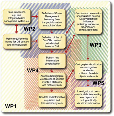
Definitions, structure, and methods of individual work packages (WPs)
WP1 Project management
responsible person.: M. Konečný
The main task is management of the research project, control of results of individual partial tasks and their finalization. WP1 provides technical maintenance, contracting of programming works, and communication with crisis management institutions. WP1 also includes publication of results of the research plan.
WP2 Databases, knowledge management, and support of crisis management decision-makingresponsible person.: J. Kolejka
Main objectives of WP2 are status evaluation of crisis management databases, development, formulation, formalization, and algorithmization of procedures for support of decision-making, design and testing of possibilities of further extensions of existing databases. This task can be performed only on basis of interdisciplinary integration of data and knowledge of natural, economic, and social aspects of environment.
WP3 Time-space modeling, classification techniques and data mining
responsible person.: J. Michálek
The main goal of the WP3 is to establish a link between statistical methods suitable for object classification and time-space modeling and geographic infrastructural data warehouses. Another task is computer implementation of selected classification methods, estimation of their efficiency and applicability and development of new techniques specific for data structures of considered system databases.
The aim is to further develop both standard methods of time-space modeling, in particular those based on regression and kriging, and also brand-new techniques of functional modeling such as data representation via wavelet expansions or their various generalizations using even nonorthogonal and/or overcomplete bases – so-called frames – in order to describe prediction of time-space series which are crucial in dynamic cartographic visualization. Functionality of the methods will be verified both on simulated and real data retrieved from available databases.
Another goal will be researching and developing of methods originating from artificial intelligence, particularly in relation to knowledge-based systems and data mining from time-space and alphanumeric data warehouses. These methods will provide intelligent tools for both visualization and data analysis to support efectively the management of crisis situations, highest priority being given to their usability in mobile devices operated under unfavourable terrain conditions.
WP4 Dynamic cartographic visualization
responsible person.: V. Talhofer
The main objective of WP4 is analysis of the entire system of geoinformation infrastructure from the point of view of its functionality for cartographic visualization oriented on dynamic visualization, analysis of methods and tools of dynamic cartographic visualization, concept design, concept validation on testing samples, and elaboration of a pilot project. The task also includes designing a communication system providing maximum possible speed and stability of data transfer, independence on potential crisis situations, and functioning under all circumstances.
WP5 Perceptional aspects of visualization in crisis management
esponsible person.: J. Švancara
The main objective of WP5 is to provide support for cartographic visualization from he point of view of user's interaction with this visualization. This concerns provision of visualization ergonomics both in normal conditions and in crisis situations.
Diagram of WP interaction
Head of the team:
Milan KONEČNÝ
Mail address: Masaryk University, Faculty of Science,
Department of Geography, Laboratory on Geoinformatics and Cartography
Kotlářská 2, 611 37 Brno
Officce: pavilon 5, first floor, door number 01030b
Tel.: +420 - 549 49 5135
Fax: +420 - 549 49 1061
E-mail: konecny@geogr.muni.cz